Where did the Wall actually run?
The Berlin Wall fell on 9 November 1989. An event of the century. We take a journey into the past.
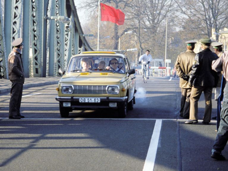
Where did the Wall actually run? Was this in the West? Where did the East begin? At Checkpoint Charlie in Berlin, all the old certainties have disappeared. Now East and West have ceased to be distinguishing features. Now people divide into stylish and dull, hip and uncool, Kreuzberg and Mitte, poor or sexy. Only the students dressed in their imitation Red Army or US Forces uniforms remind the tourists that this was where a border once separated two worlds. It is also where, in October 1961, two months after the construction of the Wall, Russian and American tanks confronted one another.
When did the 160-kilometre Berlin Wall and the 1,400-kilometre inner German border actually disappear? Was it immediately after the peaceful revolution in 1989, when the concrete was removed or taken away as trophies by “Wall woodpeckers”? Did it disintegrate with the internal mass migration that began after reunification in 1990, when inhabitants of Leipzig and Erfurt looked for work in Stuttgart and Frankfurt and young people from Stuttgart and Frankfurt moved into Prenzlauer Berg? Or is it still there, not as a physical frontier, but as a barrier in people’s minds? It’s time to look for the traces of the past between the Brandenburg Gate and the former Elbe border.
The most popular piece of the Wall lies between the Berlin districts of Kreuzberg and Friedrichshain. The East Side Gallery is 1.3 kilometres long. The section of the Wall depicting Honecker and Brezhnev engaging in a Socialist fraternal kiss is Berlin’s most famous Wall artwork. Since it was painted in February 1990, it has become more a symbol of unity than division. Much more important is the memory of the division, of the 28 years in which there was a death strip between the German Democratic Republic and the Federal Republic of Germany and between the Western Sectors and the Soviet Sector of Berlin.
The story of this division is not only told by Checkpoint Charlie, but also by the Berlin Wall Memorial in Bernauer Strasse. The demarcation line ran through the middle of the densely built-up central districts of Berlin from 13 August 1961 until 9 November 1989. The pictures of the East Berliners who jumped out of their windows to freedom went around the world. Today, Bernauer Strasse is the only place where you can experience the Wall in cross-section – with the Hinterland barrier, the death strip and the actual Wall itself.
The markings for the former sector boundaries in Berlin’s city centre are more restrained. To the left and right of Checkpoint Charlie, where signs still stand with the famous warning “You are leaving the American Sector”, there is only a line of cobblestones in the road documenting the former course of the Wall. The words “Berlin Wall 1961–1989” are engraved on bronze plaques in the ground. The stories that this low-key band of stones conceal are now almost inconceivable – above all, for younger people.
How elastic our memory can be. When the GDR began building the Wall on 13 August 1961, the Second World War had come to an end only 16 years earlier. Now, on the other hand, a quarter of a century has already passed since the fall of the Wall. Once the American and the Soviet sectors began at Checkpoint Charlie, today an expedition into history begins at Friedrichstrasse.
Memories of the division are most emotional when they come unexpectedly. For example, at the pillars that intermittently line the Berlin Wall bicycle path. Unlike in the city centre, West Berlin’s border with the surrounding region did not cut through an urban area, but was a boundary between town and country. It was where refugees repeatedly attempted to escape to West Berlin. A former border tower in Nieder Neuendorf keeps this memory alive. On 24 January 1963, Peter Kreitlow, just 20 years old at the time, was shot by Soviet troops while attempting to cross the frontier, which ran along the middle of the Havel. There are 29 pillars along the course of the Berlin Wall, a total of 136 people died.
Someone was shot because he wanted to swim across the river? Now that no longer seems to make any sense. Nor does it that a metal fence blocked East Germans’ view of the river Elbe, which formed the “inner German” border for 94 kilometres of its course. Villages that lived on and with the river for centuries were suddenly cut off from it, some were even relocated. One of these deportations was given the name “Action Vermin”. Those who remained were no longer able to see the river, just smell it and hear the birds on it.
Where was the Wall actually? Not much of it is left: one section at Niederkirchnerstrasse, right next to the state parliament building; one section at the Invalidenfriedhof, the cemetery at Spandauer Schifffahrtskanal; and finally the section at today’s East Side Gallery, which formed the boundary between Friedrichshain and Kreuzberg. After 9 November 1989 and the reunification of Germany on 3 October 1990 people no longer wanted to be reminded of the Wall, the mark of division was supposed to disappear.
Only those who know what it is like for a city to be suddenly cut into two halves can understand why one word passed people’s lips hundreds of thousands of times in the days following 9 November 1989: “Amazing!” ▪

